Wednesday 21 September 2011

Swiss Peaks 2011

Saturday/Sunday August 7th/8th, 2011
Mt Rogers, Mt Grant, Mt Fleming, Swiss Peak - 3169m
Synposis: 4 1/2 out of 5 stars. Great day in the mountains, fantastically exposed climbing on mostly solid rock and a real feeling of doing something that doesn't get done every day. One of the summit cairns still had the first ascent noted.

Met the night before at the Hemlock Grove picnic area, Brian went early but no camping spots so bived there.  Great evening, lots of stories and a few beers then borrowed Brian’s biv sack and with the help of earplugs had a good nights sleep.  Up 7:30ish to a great breakfast (thanks Andrew), a good deal of organizing and off to the visitors centre for all the legal paraphanelia.  Hit the trail at 11 am, nice day with great views.  2.8 km trek but just over 800 metres of elevation gain.  Arrived at Hermit Meadows at roughly 2 pm after a long lunch on the trail, elevation 2135m.  Got organized, lazed about and scampered up the moraine for a look about.  Bunked with Brian on one of the great wooden tent platforms and after an awesome meal, some scotch, rye and tequila turned in relatively early.


Sunday up at 4:45 am out of camp at 5:45.  A little bit of up and down as we headed towards the toe of the glacier.  Moderate scrambling up glacier scrubbed rock lead to the toe at 7:20 am (2525m).  We roped up, debated crampons however elected to put them on as there was some bare ice around.  In retrospect taking the gentle slope to climbers right would have been easier as a few rolls on the direct route.  Brenda and Andrew on one rope and Brian and I on another, both 30m’s.  As we approached the Rogers/Grant col it steepened nicely however great snow for step kicking.  The schrund was easily passed on the right and Brian and I kept the rope in glacier travel until past.  After that Brian untied and I simply dragged the rope up, Andrew and Brenda also untied.  Pretty straight forward, although a bit of a huff.  We went around some rock on the left near the col, more snow than typical years.  Gained the col at 9:30 am (3081m).  


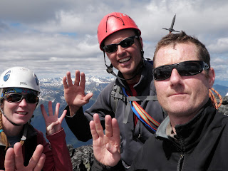
Mt Rogers is the highest of the bunch and to the climbers left, straightforward snow slopes lead to the summit along an interesting snow ridge.  Just past the summit was a rocky outcrop with a cairn.  Photo’s were taken at 10:00 am (3169m).  Back down to the col and along the snow to gain the rock on the way to Mt Grant.  We found out afterwards it would have been best to remain on the snow to the 2nd or even 3rd little col however good fun.  Ran into an interesting chimney down climb that was fairly committing.  Easy enough to go around however we all squeezed through and I may have dented my camera.  Mt Grant barely feels like a summit as quite flat however great climbing on blocky granite with some quartzite apparent.  The exposure started to increase.  Hit the top of Grant at 10:15 am, took more photo’s and carried on. 


The climb up to Fleming was probably the best rock, a few pauses to select the best route but great, exposed rock.  We took turns leading the crew and it was great fun.  The sky stayed blue and the views were incredible, especially of Sir Donald.  The rope stayed in the bag although there were moments.  The guide book indicated ½ hour between summits however that is a little keen.  Fleming was a great summit, very exposed with just enough room for all of us to nestle in the rocks. 


We stopped for some lunch before down climbing to the Fleming/Swiss col and the started up Swiss, no real place to bail even if we wanted to (which we didn’t).  Early on the way up Swiss there were two cornices barely hanging on.  One was part of some snow that we had to cross however given the sun, the cornice and the angle on the non corniced side we broke out the rope and did a closeline belay between a couple of blocks, all worked out well and then carried on.  Swiss was a little worse for rock quality but some sections were amazing.  Summitted Swiss at 1:40 pm after traversing around the front side and then working back along the ridge.  


Clouded over about then however descending Swiss and traversing the gendarmes on Trudel did take some time and a rap.  I rapped first, however had to hold off midway as there were a few loose blocks that needed adjusting (thanks Brian and Andrew).  It was slower down climbing, steep and more loose rocks.  I got to the snow first and started to work around Trudel, some interesting fluting in the snow.  Attempted to jump back on the rocks a few times however didn’t work out so stayed on the snow.  At one point descended to the point of being on loose rock over a very large and steep drop.  Worked my way back on the snow and guided everyone higher.  Finally gained the Swiss/Trudel col at 3:25 pm (3023m).


Given the time of day and the complexity of Trudel we elected to descend the col, fairly steep snow however didn’t require crampons or a rope.  Stayed fairly focused as some rocky outcrops near the bottom however descended the couloir in ½ hour and jumped into glacier mode, stayed pretty cloudy until close to camp however not a hint of precipitation and not much wind.  Made it back to the toe of the glacier at 4:40 pm and back to camp an hour later for a 12 hour day and 1300m.  However not over, Brian cooked us up some Ichiban and we broke camp at 6:30 pm after using the great throne - what a view!  Made it back to the car in 1 hour, mostly by myself.  Great lighting as the sun was getting low.  Had time to clean up and change before the others arrived and drove back to Canmore.  Great, great day.


For all the pix: https://picasaweb.google.com/114054189196114208631/TheSwissPeaksRogersPass2011


Monday 19 September 2011

Mt Allan/Collembola Scramble 2011

Sept 18th          Mt Allan 2819m, Mt Collembola 2758m


It was Deanna's birthday weekend and the ridge walk from the north was something on her tick list for awhile so game on.  Forecast was for a cool morning so we got off to a slow start and arrived at the Deadman's Flats parking area at 1385m at about 8:45 am and were off on our mountain bikes at 9:00.  The bikes made a huge difference as the first few km's weren't very steep and we made good time, then it reared up a bit and did a little hiking and biking.  Not much for view as we were deep in the trees following the centennial trail with brief glimpses of Pigeon to the SW.  We warmed up quickly once we started to climb, we ignored the various trails off to the right and found a good place to leave the bikes after 1 1/2 hrs and a gain of 450m.


Carried on up the trail, to realize that we should have pushed it and taken the bikes further up to the intersection with the trail off Collembola where there is a small cairn.  Just after the trail started to traverse to the right angling up and towards Allan.  Great news as all the other options appeared to lose a lot of elevation to gain the correct ridge.  Eventually came out at a nice alpine meadow at about 2200m in the bowl formed by the two mountains.


Then quickly gained the north ridge of Mt Allan and popped out of the trees to great views all around.  The entire route up to the top is part of the centennial trail and well marked with orange squares.  Pretty straight forward ridge scramble however it was made a little more alpine like with snow and howling winds.  We had to brace ourselves a couple of times to keep from being blown over and attempted to keep to the lee side whenever possible.


Eventually made it to the top of Mt Allan just before 2 pm, given the gale force winds and the threatening clouds from the west we headed down the Allan/Collembola col which turned out to be much more easy going than it looked from the initial ridge.  Stopped in the sun for lunch and headed up the grassy slope towards the first hump to gain back some of the 350m lost.  It was easy going up to the top of the hump however a bit of interesting rock scrambling down the other side which took a bit to figure out.


Carried on and topped out on Collembola at 4 pm with the wind still a force to be reckoned with. As well we started to get a some small hail from time to time as the clouds got closer just to help keep us moving.  The north side of the top of Collembola required some route finding to get through some steeper rubbly ledges, it seemed to go most easily right off the top and the route actually ducked to the east side of the ridge for a short bit.  After that it was a case of making our way down steep grass interspersed with scree bits and once we came around the corner and could see north our trail up became obvious and we realized that there would be only a short treed section before regaining the original centennial trail.  Found an obvious path through the trees and hit the trail at 2025m at 6:00 pm.  After that it was a quick descent to the bikes and then a very quick descent with the bikes which made a huge difference and we were at the car at 6:45 pm.


Great day, it would have been a little more relaxed without the wind however never had too much precipitation.  If I were to do it again would likely do it in the reverse so the scrambly bits would be on ascent rather than descent and earlier in the day.  After all of the up and down it ended up being a 9:45 hr and 2300m day so a bit of exercise as well.

Thursday 15 September 2011

Mt Cline 2011

Sunday/Monday  Jul 31/Aug 1, 2011 Mt. Cline 3361 metres, 11,027 feet
Synopsis: 3 1/2 stars out of 5, an 11,000er in a remote and interesting setting, great to see familiar peaks from another vantage point however the notches were the most interesting bit of climbing.


We all met in Lake Louise, Brian coming from Alexandra ACC Calgary section camp.  Left Louise at about noon in two vehicles as I was heading back to Edmonton afterwards.  Brian had the forethought to ask about ropes and pots at the park kiosk entering the Icefield Parkway and thus had to go back to Louise for pots.  Val and I had a little extra time to get ready at the trailhead.  The day started off nice and sunny in Canmore however by the time we hit Saskatchewan crossing it was pretty cloudy and as we waiting it started to rain however was short lived.  Sara and Brian arrived and we left the cars at the Thompson Creek trailhead at 2:15 pm at roughly 1380 metres asl.  Followed Bill Corbett’s directions to the biv site and they were pretty much spot on, with the help of some flagging tape.  A fair amount of wandering in the bush through the old burn however a good trail for most of it.  We did go too high just before entering the trees for the traverse right however spotted flagging and was easily remedied.   Great views of the David Thompson valley and front ranges.  Gained the two lakes and chose a bivy site just at the far end at 2340 metres, a gain of just over 1000 m after 4 ½ hours.  Beautiful spot however turned out to be fairly breezy.


The bivy site is in a basin with high walls all around, especially to the west.  The clouds were screaming by and we really couldn’t see what the weather would be until it was on us.  Brian and I tucked in behind some bush with our biv sacs and the gals put up their one man tents.  Just as we had everything laid out it hailed for a bit and then rained.  We scrambled to get up Brian’s sill tarp and it resulted in a Cajun style supper – blackened!  Got to bed about 9:30pm and had the sill tarp arranged tent fashion over our heads however the wind blew hard much of the night, from the other direction – lots of flapping and not much sleeping however warm and dry.  


We both slept through alarms set at 5:30 am, however Brian woke at 6 to save the day, a high cloud hid any blue to start however it started to burn off.  Morning gruel and off at 7:15am.  The start was obvious from the biv site and we climbed scree and snow up to a ledge and an upper lake.  Choice of scree or slabs up to the glacier and we chose the slabs.  Good travel on rock interspersed with the occasional hard snow patch and as promised Cline slowly started to come in to view a fair ways back.  At one point on the slabs could look straight down at the biv site, great view and it was clearing up nicely.  Fairly quickly gained the glacier however as it was flat and very crusty we didn’t rope up.   Pretty straight forward travel to the ridge, once on it an interesting section just before the notches.  Arrived at the first notch just after 10am at 3125 m.


Good bolt and pin on the other side, slung a block to get started and I lead.  Some light snow and slick bits in the area so I put on my crampons for the only time that day.  Easy down climb and somewhat awkward move around to the chock stone.  Climb up the other side was great fun and set up an anchor to belay the others over.  Took a little to figure out the second notch, belayed from the same anchor as the first and descended on climbers right.  Brian slung a horn and belay folks up from that end and I went last setting it up like a laundry pulley.  Great fun step across with lots of exposure.  We left the laundry pulley system in place, tied everything off and carried on at 11:45 am.  45 minutes of climbing through scree with a pretty good trail and the odd hard snowy bit and we were on the summit at 12:30am.


Very little wind, blue sky and great views in all directions!  We spent ½ hour on the summit, eating lunch and naming summits – could see all the way to the Lake Louise group, the Goodsirs, Columbia, Bryce, the Lyells and Forbes!  Down climbed quickly to the notches and made good time now that we had it dialled.  Great side pull for the step back over on the second notch.  Left the notches at 2:10pm and was back at the camp at 3:30pm.  8:20 hrs and 1050 metres climbed.  We celebrated by feasting on cherries and blueberries that Sarah brought, packed up and headed out at 4:20pm.  Interestingly after not much wind high the biv site was likely the windiest part of the mountain.  Pretty uneventful descent and we were back at the car at 7pm.  A very enjoyable couple of days, not a classic climb but the notches kept it interesting and great views from an unusual vantage point.


For all the pix: https://picasaweb.google.com/114054189196114208631/MtCline2011

Monday 12 September 2011

Mt King Edward 2011

Sat/Sun/Mon  Sep 3rd-5th, 2011        Mt. King Edward  3490 metres, 11,450 feet


Synopsis: 4 out of 5 stars, very worthwhile outing in an unbelievable setting and an 11,000er however not an absolute classic


Left Edmonton at about 5pm on Friday evening and made our way to the rendevouz at the post hotel pub where David and I met Rob and Eric and chatted over a pint.  Left 10ish to find the campground on the way to Golden full (not a big surprise) and found a roadside picnic area to crash at.  I dropped the biv sac on the ground behind the shelter and had a great nights sleep to be woken by David at 7 am.  Only after I took out the earplugs did I get a load of the ongoing noise of a generator from a trailer that came in after us and ran all night!  After a quick breakfast at the A&W in Golden we headed to Donald Station and up the gravel road.  We followed the most used trail, not taking the Bush arm at the half way point, carrying on past a sign indicating a wilderness trail and drove by the right hand turn off near Bryce to the end of the road.  Saw a small black bear crossing the road in front of us, not much dust as there was some precipitation over night and quite cold.  Drove until the end of the road, organized and started hiking at 11:15am at roughly 1070m.  Crossed the river just to the left of the trail, which was below the knee but strong and cold.  Then hung up the approach shoes on a tree and headed off.  Pretty much an old logging road for a while, however there was a recent burn and logs were blocking the way.  Some had been cut by quaders however some required scrambling up and over.  Eventually came to the first cut block and cut up to the left at 1pm (1530m) and took it only to discover that we were one cut block too quick.  Some bush wacking ensued as we made our way through the forest to the next cut block and along until we regained an old quad trail.  We joined the the trail at the top of the second cut block at 1:45pm (1680m) near some flagging, good to know we were on the right track.  The quad trail beat an undulating path through the forest however it was fairly easy going.  Eventually the forest thins out and alpine meadows appear.  We then angled north east to gain a moraine and finally grey glacier scrubbed rock.  We found a great biv site on flat rocks after hiking for 5 ½ hours at 2120m after 1180m of elevation gain within sight of the toe of the glacier and set up camp.  Perfect weather, without much wind and quite cool once the sun went down.


Next day up at 3:30 am, groggily boiled the porridge water and got the gear together.  Temperature was 4 above so a not bad freeze.  Left camp at 4:20am and headed up blindly towards the toe of the glacier, very happy to have my new headlamp - a gift from D and blindingly bright.  After just 20 minutes got the rope out and tied in for the glacier.  Surprisingly steep for a short bit with interesting frozen texture (at least by headlamp).  Climbed up in the dark on the glacier, ended up a little east however after seeing the crevasses afterwards probably a good thing.  Did cross an area or two heavily crevassed and I fell up to my waste at one point although snow bridges were generally good.  Turned the head lamps off shortly before 7am and stopped for a snack and to look around.  The alpine glow on Bryce was stunning, perfectly clear sky although still chilly.  Worked our way towards the west ridge of King Edward and as we crossed the last hump a snow slope came into view with thankfully not much descent to gain it.  Crossed over and zig zagged up the snow slope with the ropes in glacier mode.  Good stiff snow, went straight up the last bit and gained the ridge line just after 8am at 3000 metres.  Shortened the rope between the three of us and left a long line out to David to lead.  However around the corner found fairly well bonded scree on a steep slope with a bit of a path.  
Wound our way through a few snow bits and eventually chucked the rope.  Made our way to a snowy col in a mid level cliff band.  Climbed the snow for a bit and then on the rocks with crampons and made our way up to a belay David created only about 10 metres above.  Good fun although spent most of my time ensuring not to get stepped on with the crampons above.  Emerged to see the summit block above and well packed scree on the way.  Made our way up the scree to the summit block, very interesting rock formation.  Skirted it on climbers right and passed one weakness and then Rob belayed David up the next snow gully.  David set up an anchor in the rocks on the left and then lead a 25m mixed pitch up to the summit ridge.  All there although with the exposure happy with the rope.  We then made our way up the summit ridge minding the cornices for a short bit and hit the top at 11:20.  Very clear day with great views in every direction.  Especially happy to see Columbia, the Twins, Snowdome and Kitchener from the other direction.  Took some photos however somewhat windy and cold so decided to descend a bit to get out of the wind for lunch.  Setting up the first rap took a bit of fiddling and Eric hadn’t rappeled before so was lowered, then found a station below for a final short rap to the snow.  Eric and I then scampered around the corner to the edge of the summit block and waited for the other two.  Then a case of making our way down the scree, some good loose bits to aid the descent.  Easily found a rap station near where we climbed in mid band and scrambled further down the scree.  Due to the sun (although still wearing a toque) elected not to follow our up track to the south facing snow slope and headed further down towards the glacier.  Ended up on scree just above the slab steps above the glacier.  I was a little worried however once we got going went easily across wet snow slopes to a final rap anchor and down to the glacier.  Gained the glacier at about 3:30pm at 2780m and immediately it got very warm.  We attempted to work our way to the eastern edge of the glacier above where we had gained it however stopped by broken glacier.  Instead made our way further down on gently sloping glacier with not a lot of crevases.  Eventually worked our way down and exited the glacier at 5:30pm at roughly 2400m.  Wore crampons all the way to the summit however took them off for the scree down and the glacier slog.  Made our way slowly back to camp on the glacier scrubbed rock, actually a nice change from the glacier and easy going.  Long day however lots of variety and went by quickly.  Totaled 14 hours and 1520m of elevation gain so fairly full day however perfect weather.  

After a great sleep got up at 6:30am to get to the river crossing before too strong.  Off at 7:30am and made it down (the correct cut block) in 3:10 hrs including river crossing.  A little higher but not much above the knee.  Great views of Bryce, the Bush Group and many others.  Nice and warm when got to the car for a cold beer and wash up in the creek.  Great trip, a fantastic area!


For all the pix: https://picasaweb.google.com/114054189196114208631/KingEdward2011