Fri, Sat, Sun Aug 7th-9th, 2015 Recondite Peak 3356 metres
Synopsis: 4 stars out of 5, if you enjoy long days with plenty of solitude and plenty of Rockies choss (a bit of an acquired taste I realize).
This trip was an Alpine Club trip that I led, and we delayed the start by two days looking for a weather window, which came through as advertised! We had a slightly longer and higher approach given that Helen Lake area was closed due to bear activity.

Mike, Jamshaid and I left the mosquito creek parking lot at 7:30 am Friday morning. Fortunately I had checked out the start of the trail and turnoff up to Dolomite Pass the previous weekend. 1 hour in we made it to the third bridge along the trail to Mosquito Creek and back tracked a bit to find the easiest way through the bush. After following game trails with some moderate bush whacking we popped out at tree line and followed some very interesting terrain up to the pass, which was actually a fair way in. 11 am and 2590 metres we topped out and started to head down into the head waters of Dolomite River.

Rather than dropping down and picking up the trail we stayed high to our right, eventually skirting the waterfall and heading down into a small patch of bush. It actually worked out well as we popped out of some bush just across an easily crossed bit of river and jumped on the trail. It was just before 1 pm and at 2210 metres. We had a sense that not many people went this way, so it was a bit of a surprise when I found a Hot Wheels plastic bag with happy birthday written on it stuck in a bush - it looked like it blew in.

Given that there were more stream crossing to come, we carried on with bare feet in wet sneakers. It worked well although one of our party had a blister issue. Once on the trail it was pretty straight forward travel on a clearly defined trail, with a surprising amount of descent. Fortunately water levels were pretty low so the two subsequent crossing were pretty much non events.

We finally came around a corner to see Isabella Lake in the distance. With the warning of slopping through the mud in our minds we stayed left and at one point got sucked into gaining elevation looking for a better trail. Not to be, the best way appears to be along the gravel bars and eventually picking up a trail just on the edge of the trees. We made the spectacular Park Warden hut at 4:15 pm and it was at an elevation of 1876 metres.

We carried on just a couple of km's past the end of the lake (didn't see a campground) and came to an obvious place to recross the Dolomite River that went over to an old horse camp. It was funny to catch the first trail sign of the trip this far in.

Once across there was an obvious trail heading along the opposite side of the river bank, that lead shortly thereafter to a spot to cross the Siffleur River. Once on the opposite bank, we got our climbing boots back on. The old horse trail is pretty over grown and we quickly (too quickly) head up and right.

In looking at the beta we had and the topo, I was concerned about continuing along the Dolomite and wanted to cut up quickly. The others weren't convinced but followed and it turned into a bit of a bushwhack. We got into some thick bush and you really couldn't tell looking if we were going to pop out in the correct valley or cut right too early and find ourselves back in the Siffleur valley. Fortunately Jamshaid had a GPS and it helped immensely.

After some time, we came to the edge of the bush we were whacking our way through on a scree slope. After considering it we took a descending line and ended up in the valley floor, fortunately upstream of the waterfall mentioned in the beta.

It became pretty apparent that we weren't going to make Corbett's or Collier's biv site before dark. At about 8:30 pm we found a flat bit about half way along the valley and set up camp. It had been a little over 13 hours and 1300 metres of elevation gain, no doubt not helped by some of the decision making along the way. However we could see the end of the valley (not Mt Recondite yet). The three of us quickly set up camp convinced that we had a good shot at the summit the next day. It was a beautiful valley with really no signs of any human activity.

Given the previous days exertion, we set the alarms for 6:00 am and after a bit of a leisurely breakfast were on the road at 7:30. We actually had a discussion about how far to move camp towards the highway should we be up and down quickly, I should know better! It is actually pretty surprising how close you need to be to Recondite to actually see the summit, that's it on the left in the photo below.

We followed the right side of the river as far as we could before hoping across. Given that Collier's biv site was a more direct route to the summit we decided to stay on the near side of Recondite's Ridge and pick our way through the bush. We started up out of the valley at 8:50 am (2200 metres).

Almost exactly an hour later, the three of us popped out of the bush and climbed up to a grassy bench. A very cool area, it would have made a great camping spot. We stopped and left some items we wouldn't need on a large bolder and made our way up the valley before climbing the scree slopes to gain the ridge.

Once on the ridge, it was interesting to see down the far side to Collier's biv site, it would have worked equally as well and being a little higher would have led to a shorter summit day.

Ahead lay some interesting rock that made for easy ascent if you avoided the occasional dusting of marbles. Very textured so traction was great and calf workout reminiscent of a long ice climb.

It eventually petered out and became the more classic Rockies scree. Route finding wasn't as straight forward as I expected (is it ever?) and we climbed too high on the tower and ended up descending a bit before finding relatively straight forward terrain to climbers right. Straight forward it a Rockies kind of way.

Shortly beyond regaining the ridge, we climbed a second tower thinking it would be the rap station however it was clearly more than 30 metres down the other side. After a bit of faffing about we realized that we needed to pass this on on the right as well and found a way down to the right and onwards.

Interestingly enough, we found a coiled 1/2 rope stashed under some rocks very close to the point we originally thought we would be rappelling from. We originally planned to take it back and post it to see who turned up and find out the story behind it. As luck would have it we stashed it for the return trip and found a better way back so it is still there.

We finally did reach the rappel station at 2:45 pm at roughly 3340 metres. To save weight we chose not to bring crampons and mountaineering axes. We did bring an extra 30 metre rope in case it was slick on the final slope, thinking that someone may appreciate a belay. Once at the rap station I realized the error of my thinking, the top was a choss heap and there wouldn't be any pro. Fortunately it worked out, as expected there was very little snow in the notch and none above.

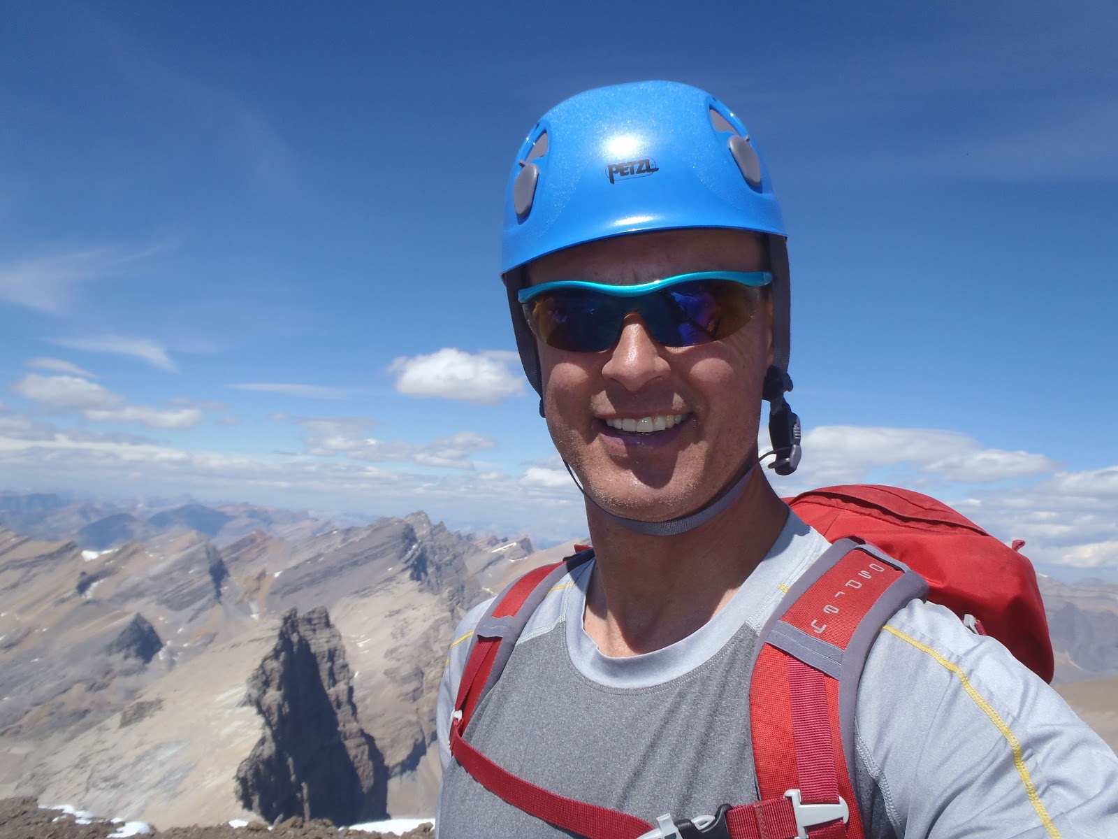
At last, we found ourselves on the top of the rubbly summit at 3:00 pm and after a bit of a break enjoying the view and some lunch we retraced our footsteps. We were the first party to sign the summit register in two seasons and it made for interesting reading, the names of a lot of local legends were in it. On our way down, the most fun of the day was reclimbing the notch that we rappelled down with the rope left in place.

The return was much the same although we allowed ourselves to get sucked into attempting to rappel the first block by some tat we saw on the way up. It turned out to be a mistake as it resulted in stuck ropes with the ensuing drama and lost time.

The remainder of the descent was straight forward, if not quick. The final scree slope back to the meadow as a good boot ski and once down to the meadow we collected our stashed gear. At this point Jamshaid found a better way through the foilage to the valley bottom although part way down I took a tumble and broke my ski pole.

The three of us made it back to the biv site at 8:30 pm and had a good laugh at ourselves for underestimating the day and thinking we would move our biv site closer to the road. Come to think of it it's a lesson I've learned a few times. Summit day on Recondite has a bit to it, from where we camped it was just short of a 14 hour day and 1500 metres of elevation gain.

The next day was obviously a reversal of the first day, with a couple of improvements. We left the biv site at 8 am and angled slowly upwards towards the patch of trees turning the corner into the Dolomite valley. The was everything from 2 steps up, 1 slide back scree to hard morraine. Minus a pole I was at a bit of a disadvantage until Mike did an amazing job of fixing it using tightly wound surveyors tape, followed by a layer of duck tape. 1/2 a season later it's still taking abuse!

Near the trees we did a bit of awkward climbing to enter them on the shoulder. In following our noses and Mike's readily apparent bush sense, we found a pretty clear way down staying descenders right close to the top of the cliff band. It eventually joined the old horse trail back towards the Siffleur River crossing. The horse trail came and went but there were old tree blazings to help us along.

The rest was pretty much a reversal of day one, with the exception of the area just past lake Isabella. We did much better following the gravel beds on the right hand side of the valley, eventually rejoining a beaten path in pretty obvious spot.

In keeping with our theme of finding odd stuff along the way, Mike came across a single insole along the trail near the Siffleur crossing. Day three proved to be every bit as long as the first two as we were at the trail head in 13 1/2 hours with an elevation gain of 1,000 metres.

It was an odd feeling at the end of the trip; I'm very glad to have the experience of getting back there, and equally as glad we bagged it and I don't have to go back! The gpx coordinates indicate it was 87.9 km of travel and 7,548 metres of elevation gain, which helps explain why it took me a week to recover.
This trip was an Alpine Club trip that I led, and we delayed the start by two days looking for a weather window, which came through as advertised! We had a slightly longer and higher approach given that Helen Lake area was closed due to bear activity.

Mike, Jamshaid and I left the mosquito creek parking lot at 7:30 am Friday morning. Fortunately I had checked out the start of the trail and turnoff up to Dolomite Pass the previous weekend. 1 hour in we made it to the third bridge along the trail to Mosquito Creek and back tracked a bit to find the easiest way through the bush. After following game trails with some moderate bush whacking we popped out at tree line and followed some very interesting terrain up to the pass, which was actually a fair way in. 11 am and 2590 metres we topped out and started to head down into the head waters of Dolomite River.

Rather than dropping down and picking up the trail we stayed high to our right, eventually skirting the waterfall and heading down into a small patch of bush. It actually worked out well as we popped out of some bush just across an easily crossed bit of river and jumped on the trail. It was just before 1 pm and at 2210 metres. We had a sense that not many people went this way, so it was a bit of a surprise when I found a Hot Wheels plastic bag with happy birthday written on it stuck in a bush - it looked like it blew in.

Given that there were more stream crossing to come, we carried on with bare feet in wet sneakers. It worked well although one of our party had a blister issue. Once on the trail it was pretty straight forward travel on a clearly defined trail, with a surprising amount of descent. Fortunately water levels were pretty low so the two subsequent crossing were pretty much non events.

We finally came around a corner to see Isabella Lake in the distance. With the warning of slopping through the mud in our minds we stayed left and at one point got sucked into gaining elevation looking for a better trail. Not to be, the best way appears to be along the gravel bars and eventually picking up a trail just on the edge of the trees. We made the spectacular Park Warden hut at 4:15 pm and it was at an elevation of 1876 metres.

We carried on just a couple of km's past the end of the lake (didn't see a campground) and came to an obvious place to recross the Dolomite River that went over to an old horse camp. It was funny to catch the first trail sign of the trip this far in.

Once across there was an obvious trail heading along the opposite side of the river bank, that lead shortly thereafter to a spot to cross the Siffleur River. Once on the opposite bank, we got our climbing boots back on. The old horse trail is pretty over grown and we quickly (too quickly) head up and right.

In looking at the beta we had and the topo, I was concerned about continuing along the Dolomite and wanted to cut up quickly. The others weren't convinced but followed and it turned into a bit of a bushwhack. We got into some thick bush and you really couldn't tell looking if we were going to pop out in the correct valley or cut right too early and find ourselves back in the Siffleur valley. Fortunately Jamshaid had a GPS and it helped immensely.

After some time, we came to the edge of the bush we were whacking our way through on a scree slope. After considering it we took a descending line and ended up in the valley floor, fortunately upstream of the waterfall mentioned in the beta.

It became pretty apparent that we weren't going to make Corbett's or Collier's biv site before dark. At about 8:30 pm we found a flat bit about half way along the valley and set up camp. It had been a little over 13 hours and 1300 metres of elevation gain, no doubt not helped by some of the decision making along the way. However we could see the end of the valley (not Mt Recondite yet). The three of us quickly set up camp convinced that we had a good shot at the summit the next day. It was a beautiful valley with really no signs of any human activity.

Given the previous days exertion, we set the alarms for 6:00 am and after a bit of a leisurely breakfast were on the road at 7:30. We actually had a discussion about how far to move camp towards the highway should we be up and down quickly, I should know better! It is actually pretty surprising how close you need to be to Recondite to actually see the summit, that's it on the left in the photo below.

We followed the right side of the river as far as we could before hoping across. Given that Collier's biv site was a more direct route to the summit we decided to stay on the near side of Recondite's Ridge and pick our way through the bush. We started up out of the valley at 8:50 am (2200 metres).

Almost exactly an hour later, the three of us popped out of the bush and climbed up to a grassy bench. A very cool area, it would have made a great camping spot. We stopped and left some items we wouldn't need on a large bolder and made our way up the valley before climbing the scree slopes to gain the ridge.

Once on the ridge, it was interesting to see down the far side to Collier's biv site, it would have worked equally as well and being a little higher would have led to a shorter summit day.

Ahead lay some interesting rock that made for easy ascent if you avoided the occasional dusting of marbles. Very textured so traction was great and calf workout reminiscent of a long ice climb.


Shortly beyond regaining the ridge, we climbed a second tower thinking it would be the rap station however it was clearly more than 30 metres down the other side. After a bit of faffing about we realized that we needed to pass this on on the right as well and found a way down to the right and onwards.

Interestingly enough, we found a coiled 1/2 rope stashed under some rocks very close to the point we originally thought we would be rappelling from. We originally planned to take it back and post it to see who turned up and find out the story behind it. As luck would have it we stashed it for the return trip and found a better way back so it is still there.

We finally did reach the rappel station at 2:45 pm at roughly 3340 metres. To save weight we chose not to bring crampons and mountaineering axes. We did bring an extra 30 metre rope in case it was slick on the final slope, thinking that someone may appreciate a belay. Once at the rap station I realized the error of my thinking, the top was a choss heap and there wouldn't be any pro. Fortunately it worked out, as expected there was very little snow in the notch and none above.
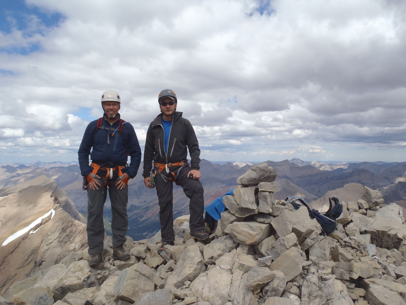
At last, we found ourselves on the top of the rubbly summit at 3:00 pm and after a bit of a break enjoying the view and some lunch we retraced our footsteps. We were the first party to sign the summit register in two seasons and it made for interesting reading, the names of a lot of local legends were in it. On our way down, the most fun of the day was reclimbing the notch that we rappelled down with the rope left in place.

The return was much the same although we allowed ourselves to get sucked into attempting to rappel the first block by some tat we saw on the way up. It turned out to be a mistake as it resulted in stuck ropes with the ensuing drama and lost time.

The remainder of the descent was straight forward, if not quick. The final scree slope back to the meadow as a good boot ski and once down to the meadow we collected our stashed gear. At this point Jamshaid found a better way through the foilage to the valley bottom although part way down I took a tumble and broke my ski pole.

The three of us made it back to the biv site at 8:30 pm and had a good laugh at ourselves for underestimating the day and thinking we would move our biv site closer to the road. Come to think of it it's a lesson I've learned a few times. Summit day on Recondite has a bit to it, from where we camped it was just short of a 14 hour day and 1500 metres of elevation gain.

The next day was obviously a reversal of the first day, with a couple of improvements. We left the biv site at 8 am and angled slowly upwards towards the patch of trees turning the corner into the Dolomite valley. The was everything from 2 steps up, 1 slide back scree to hard morraine. Minus a pole I was at a bit of a disadvantage until Mike did an amazing job of fixing it using tightly wound surveyors tape, followed by a layer of duck tape. 1/2 a season later it's still taking abuse!

Near the trees we did a bit of awkward climbing to enter them on the shoulder. In following our noses and Mike's readily apparent bush sense, we found a pretty clear way down staying descenders right close to the top of the cliff band. It eventually joined the old horse trail back towards the Siffleur River crossing. The horse trail came and went but there were old tree blazings to help us along.

The rest was pretty much a reversal of day one, with the exception of the area just past lake Isabella. We did much better following the gravel beds on the right hand side of the valley, eventually rejoining a beaten path in pretty obvious spot.

In keeping with our theme of finding odd stuff along the way, Mike came across a single insole along the trail near the Siffleur crossing. Day three proved to be every bit as long as the first two as we were at the trail head in 13 1/2 hours with an elevation gain of 1,000 metres.

It was an odd feeling at the end of the trip; I'm very glad to have the experience of getting back there, and equally as glad we bagged it and I don't have to go back! The gpx coordinates indicate it was 87.9 km of travel and 7,548 metres of elevation gain, which helps explain why it took me a week to recover.